The GNSS receiver in a tablet gives positions to within a few metres. Getting to centimetres takes an RTK-capable receiver, correction data and a clear view of the sky. What separates GPS, GNSS and RTK, and which accuracy classes exist, is covered in GPS, GNSS, and RTK: Accuracy Classes Explained. This article describes the practical setup: what the rover and the base each do, how correction data reaches the tablet via NTRIP and the mobile network, whether the receiver sits inside the device or is attached externally, how long a fix takes and where it breaks. The device values come from the datasheets of the RobustBook models. The procedural information comes from u-blox documents and from the documents of SAPOS, the satellite positioning service of the German state surveying authorities. One gap up front: for the RuggON SPARK 7 GSS RTK, the manufacturer datasheet lists “GNSS RTK Positioning” but gives no receiver, no antenna and no accuracy. The section on the devices in our range deals with that.
Rover and base: what each side provides
An RTK setup has two receivers. The base stands on a point with a known position and sends correction data continuously. The rover is the moving receiver, here the one in or on the tablet. It calculates its position against the base data. First it reports “RTK float”, and once the carrier phases are resolved unambiguously it reports “RTK fixed”. According to u-blox, centimetre accuracy relative to the base applies only in the “fixed” state.
For the rover to attempt a fix at all, the data stream has to contain two things. The integration manual of the u-blox ZED-F9P module (revision R16, 30 October 2024) names the base observation data (messages of type MSM4 or MSM7) and a position message from the base (RTCM 1005 or 1006). The station ID in both must match. The corrections should also fit the rover’s signal configuration, meaning the satellite systems it evaluates. The ZED-F9P serves here as an example of an RTK receiver; the datasheets of the RobustBook devices do not say which receivers are fitted in the tablets.
A dedicated base suits short distances. As typical setups, u-blox describes a base and a rover a few hundred metres apart. Alternatively the rover takes corrections from a subscription service: from a fixed reference within 50 km, or from a VRS service that generates the corrections for the rover’s position. The module datasheet (ZED-F9P-04B, revision R05, 21 March 2024) gives 0.01 m + 1 ppm for RTK. It was measured on a 1 km baseline with patch antennas on a good ground plane, and the ppm part applies only to baselines up to 20 km. At 20 km distance that works out to 3 cm. The value belongs to the module, not to any of our devices.
Correction data via NTRIP and the mobile network
NTRIP is a protocol that transmits GNSS data streams over the internet. It is based on HTTP/1.1 and was developed at the Federal Agency for Cartography and Geodesy (BKG) together with TU Dortmund. In September 2004, version 1.0 became an RTCM Recommended Standard. Three roles belong to it: the server feeds in the data of a reference station, the caster, an HTTP server, distributes it, and the client receives it and passes it to the receiver. On the tablet side an NTRIP client therefore runs, either in an app or in the receiver.
In Germany the usual route is SAPOS. The service of the state surveying authorities uses more than 270 reference stations of its own and delivers corrections over the mobile internet. The HEPS service states 1 to 2 cm for the horizontal position and 2 to 3 cm for the ellipsoidal height. The data format is RTCM 3.x, and login uses a user name and password. Registration is with the sales office of the respective federal state or with the central SAPOS office for nationwide activation. The simpler EPS service delivers only code corrections and states 0.3 to 0.8 m for the horizontal position. According to SAPOS, a DGNSS-capable single-frequency receiver is enough for that; HEPS needs an RTK-capable multi-GNSS receiver and a mobile modem.
Three details decide success in daily use. First, the service wants the rover’s position back in NMEA 0183 GGA format so that it can compute corrections for exactly that location. In Rhineland-Palatinate that means at least every 10 seconds, in North Rhine-Westphalia at least every 60 seconds. With a virtual reference service, the caster delivers no corrections without this feedback, according to u-blox. Second, the mountpoint selects the satellite systems: in Rhineland-Palatinate n=3 stands for GPS, GLONASS and Galileo, and n=4 adds BeiDou. It should match the receiver. Third, the ZED-F9P discards corrections older than 60 seconds and by default falls back to a 3D or 3D/DGNSS solution. A dead zone of one minute can therefore end the fix.
For the tablet this means it needs a data connection in the field. The article 5G and LTE Built Into the Device: eSIM, Antennas, Reception in Warehouses describes which mobile options the devices have. Outside Germany other services apply, and they were not checked here.
Internal receiver, external antenna or external receiver
There are three ways to bring a rover to the tablet. They differ in where the fix is calculated and where the antenna sits.
Internal receiver
Here everything sits in the device. That is the most compact option, but it only makes sense if the datasheet names RTK. A signal entry such as “GPS L1+L5” for the Fieldbook N80G2 names the frequencies the receiver evaluates and says nothing about RTK. Whether the operating system of a tablet passes correction data to the internal receiver is not stated in any of the datasheets.
External antenna on the device
Several devices have an antenna connector so that the antenna can sit freely on a roof or a mast. The connector alone does not turn the receiver into an RTK receiver. For the antenna itself, u-blox gives rules: the ZED-F9P requires an active antenna, a patch antenna needs a ground plane of at least 100 to 150 mm diameter, and for optimum RTK performance the average signal level (C/N0) should be above 40. In a vehicle, according to u-blox, the antenna belongs in the middle of a conductive roof, without tilt, and not under the dashboard.
External receiver, for example via Bluetooth
The receiver with its own antenna calculates the fix itself, and the tablet only shows position and status. On Android this runs through the interface for test positions. The Android documentation describes the developer option “Select mock location app” as a function for faking locations for testing. According to the LocationManager reference, a position set this way is identifiable to all clients as a mock location through Location.isMock(). Anyone planning this variant should check beforehand whether the field software accepts mock positions. The status of the fix is in the GGA sentence: the quality field is 4 for “RTK fixed” and 5 for “RTK float”.
Fix times: what datasheets say and what they do not
The time between “float” and “fixed” is called convergence time. The ZED-F9P-04B datasheet gives less than 10 s for RTK when several satellite systems are evaluated, and less than 30 s with GPS only. The footnote is detailed: the time depends on atmospheric conditions, baseline length, antenna, multipath conditions, and satellite visibility and geometry. A value of less than 10 s is therefore a measurement under good conditions and not a promise for every site.
SAPOS gives no figure in seconds for HEPS. The operators only write that the networking of the reference stations allows fast initialisations. For the devices in our range, no datasheet states a fix time. Anyone who needs one measures it on site with the planned setup.
Shading and multipath: where RTK reaches its limits
The SAPOS figures explicitly apply only under conditions: according to Geobasis NRW, the accuracy depends on the receiver, on local conditions (shading) and on the satellite constellation. u-blox adds that multipath and satellite visibility at the rover and the base affect the convergence time. In practice: between house walls, under trees or next to large metal surfaces, the fix takes longer or does not happen. What multipath propagation is, the article on accuracy classes explains.
If phase tracking breaks off, the rover falls back to “float” and tries to restore the fix. For difficult environments the ZED-F9P has had a conservative mode since firmware HPG 1.50. It accepts a longer time to the first fix or more float solutions in return for being almost certain once there is a fix. u-blox explicitly names surveying in an urban environment for this. For measurement on a construction site (see Measurement and Documentation on the Construction Site), the rule of saving only points with the status “fixed” pays off.
What the datasheets of our devices document
The table shows five devices from our range. It lists what each datasheet says about GNSS, RTK and antenna connector. Where a field reads “not stated”, the datasheet contains no entry on it.
| Device | Display | Ingress protection | GNSS and RTK per datasheet | Antenna connector per datasheet |
|---|---|---|---|---|
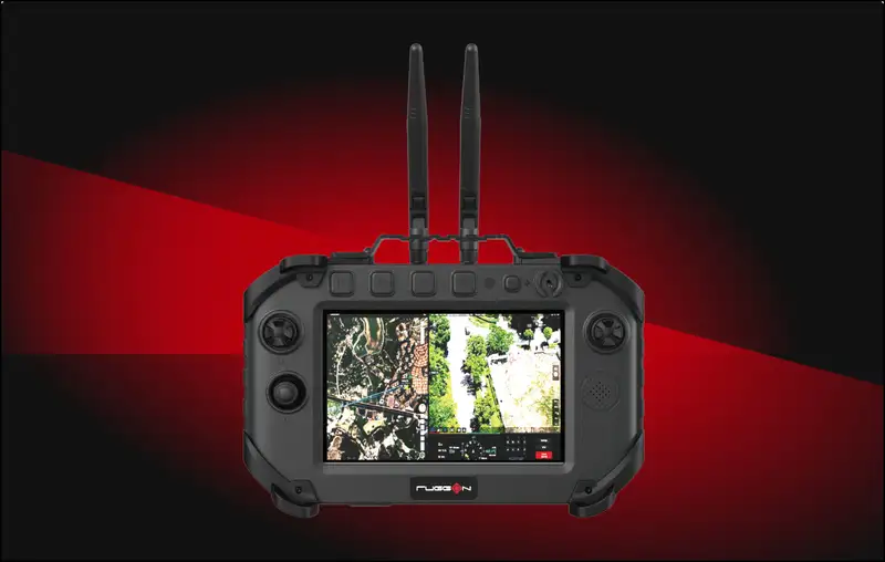
| RuggON SPARK 7 GSS RTK Android 14 Flight Controller | 7 inch | IP65 | “GNSS RTK Positioning” listed as a feature; receiver, constellations and accuracy not stated | Not stated |
| RuggON VORTEX 07X | 7 inch | IP65 | Optional GNSS (GPS/Galileo/GLONASS/BeiDou/QZSS), dead-reckoning or RTK | Not stated |
| Fieldbook N80G2 | 8 inch | IP67 | GPS L1+L5; RTK not stated | External GPS antenna × 1 |
| Fieldbook N101 | 10.1 inch | IP67 | GNSS in the expansion slot; RTK not stated | External GPS antenna connector (PIFA) × 1 |
| Getac ZX80 | 8 inch | IP67 | Optional dedicated GPS L1/L5 (GPS, GLONASS, Galileo, BeiDou); RTK not stated | Optional RF pass-through for GPS, WWAN and WLAN |
The SPARK 7 is at the centre because RTK is in the product name. The manufacturer datasheet (RuggON, as of 8 January 2026) lists “GNSS RTK Positioning” in its header. Under communication, the specification table names Ethernet and Wi-Fi 6E/BT. A GNSS receiver, an antenna, an accuracy, a fix time or a mobile modem are not given there.
What is documented is what else defines the device: a ground station for unmanned systems with Android 14, a 7-inch display with 1680 nits, IP65 and an operating temperature range of -20 °C to 50 °C. The datasheet does not say whether “GNSS RTK Positioning” refers to the position of the ground station itself. For RTK work, three points should therefore be clarified with the manufacturer before ordering: which receiver is fitted, how an antenna is connected, and by what route the correction data reaches the device. The device as a drone controller is covered in Controller with display for drones.
For the VORTEX 07X, RTK appears in the text of the technical data (“or RTK supported”), as part of the optional GNSS equipment. For the SPARK 7 it appears only as a feature in the header. The Fieldbook and Getac models have connectors for a GPS antenna, optional on the ZX80. RTK is not in their datasheets; their route would be a setup with an external receiver.
Frequently asked questions
Is a tablet’s internal GPS enough for RTK?
Only if the receiver handles RTK. For the SAPOS HEPS service, the surveying authorities require an RTK-capable multi-GNSS receiver. For the coarser EPS service a DGNSS-capable single-frequency receiver is enough; there, 0.3 to 0.8 m is stated for the horizontal position.
Do I need my own base station?
In Germany not if you are registered with SAPOS and the tablet has a mobile connection. A dedicated base suits short distances and places without a network; its data stream must then contain observation and position messages.
How long does it take to get a fix?
For the ZED-F9P-04B module, u-blox gives less than 10 s with several satellite systems and less than 30 s with GPS only, in each case under favourable conditions. For the devices in our range, no datasheet states a fix time.
Which device in our range names RTK in its datasheet?
The RuggON SPARK 7 GSS RTK lists “GNSS RTK Positioning” as a feature, and the RuggON VORTEX 07X names RTK as part of the optional GNSS equipment. For the other devices in the table, RTK is not in the datasheet.
Who should take which device
Anyone looking for a controller for unmanned systems who expects RTK in the device should look at the SPARK 7 first. The RTK part is so far documented there only as a feature. Anyone who needs RTK in a vehicle will find in the VORTEX 07X a device whose technical data name RTK support, tied to the optional GNSS equipment. Anyone working in the field with a tablet and leaving the accuracy to an external receiver can take a device with an antenna connector, such as the Fieldbook N80G2 or the Getac ZX80; the tablet then only displays.
Anyone who owes documented centimetre accuracy, for example in surveying, should not rely on any one of the devices named. No datasheet states an RTK accuracy, a fix time or tilt compensation. That calls for a surveying receiver with its own performance figures. Before any setup, four things need clarifying:
- Which receiver calculates the fix, and what does its datasheet say about RTK?
- How does the correction data reach the device: mobile network, WLAN or a radio link to your own base?
- Is the registration with the state service done, and does the mobile network cover the area of use?
- Does the field software accept an NTRIP client and, where relevant, positions from an external receiver?
If you have questions about which device suits your setup, the RobustBook team is happy to help you choose.